Agro-Climatic Zones Of India

agro climatic zones of India

Agro-Climatic Regional Planning

Agro-Climatic regional planning in India was initiated in 1988 by the planning commotion. It means under the seventh five year plan; Regional planning was come into force on the basis of agro-climatic factors for balanced regional growth. The agro climatic zones factor are rainfall, temperature, soil, topography, cropping and farming system and the water resources.

Introduction

Agriculture is greatly influenced by climate and ecological factors. Agro climatic zones and agro ecological zones are geographical divisions based on specific climate and ecological characteristics. These zones aid in the identification of suitable crops, farming practices, and land management strategies for different regions.

What Is Agro-Climatic Zones

Agro climatic zones refer to areas that share similar climatic conditions, including temperature, rainfall patterns, and seasonal variations. These zones are demarcated based on the prevailing climate and are instrumental in understanding the potential for agricultural productivity in specific regions.

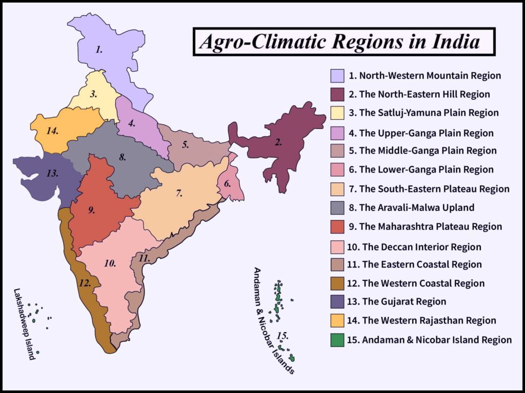
On the basis of criteria of homogeneity in agro-characteristics such as water surplus and water deficit, India was divided into 11 agro-climatic zones.

letter on , India was divided into 15 agro-climatic zones on the basis of water surplus, water deficit and cropping system.

15 Agro-Climatic Zones

  1. Western Himalayan Region.
  2. Eastern Himalayan Region.
  3. Lower Gangetic Plain.
  4. Middle Gangetic Plain.
  5. Upper Gangetic Plain.
  6. Trans Gangetic Plain.
  7.  Eastern Plateau & Hills.
  8. Central Plateau & Hills.
  9. Western Plateau & Hills.
  10. Southern Plateau & Hills.
  11. East Coast Plains.
  12. West Coast Plains & Ghats.
  13. Gujarat Plains & Hills.
  14. Western Dry Region.
  15. Island Region.

The Detailed Description Of Agro-Climatic Zones As Follows

1. Western Himalayan Region.

Area :

  1. Including Jammu & Kashmir.
  2. Himachal Pradesh.
  3. and hilly area of Uttar Pradesh.

Climate :

Climate is cool and humid

Annual rainfall :

1650-2000 mm

Crops :

  1. Wheat.
  2. Maize.
  3. Paddy.
  4. Potato.

Cropping Intensity :

Cropping intensity is lowest in Jammu & Kashmir and heights in Himachal Pradesh

To Develop This Region :

  1. Intensify the soil and water conservation planning.
  2. land utility planning.
  3. Good storage for transportation, marketing & processing.
  4. Improve water harvesting technique.
  5. Improve livestock management etc.

2. Eastern Himalayan Region :

Area :

  1. Area of West Bengal. (Sikkim, Hills of Darziling, Arunachal Pradesh, Nagaland, Meghalaya, Manipur, Tripura, Mizoram, Assam and Jalpaiguri.)
  2. Some part of Bihar.

Climate :

Climate is Humid & Sub-Humid

Annual Rainfall :

1840-3528 mm

Crops :

Main crops is :

  1. Maize.
  2. Paddy.
  3. jute.
  4. Rapeseed.

Cropping Intensity :

Shifting cultivation on 1/3rd of cultivated area, soil erosion more.

To Develop This Region :

  1. Soil and Water conservation for each watershed.
  2. Educate people about the harmful effect of land erosion.
  3. Good communication and transportation facility.
  4. Adaptation of integrated
  5. Improve farming system

3. Lower Gangetic Plain:

Area:

  1. West Bengal.

Climate:

Climate is moist humid and dry humid.

Annual Rainfall:

1302-1607 mm

Crops:

Main crops is:

  1. Rice.
  2. Jute.
  3. Maize.
  4. Potato.
  5. Rapeseed.
  6. Wheat.

Cropping Intensity:

Productivity of rice is lower than the national average 15 q/ha but the region contribute 12% of the total rice production in India

To Develop This Region:

  1. Improve the good water management and the drainage problems.
  2. Improve the extension work.
  3. Improve marketing strategy and processing of food.
  4. They dependent on monsoon.
  5. More farmer visit to improve their knowledge.
  6. Improve the electricity supply.

4. Middle Gangetic Plain:

Area:

This zone consist of 12 districts of eastern Uttar Pradesh and 27 districts of Bihar plains.

Climate:

Climate is moist sub-humid and dry sub-humid.

Annual Rainfall:

1211-1470 mm

Crops:

Main crops is:

  1. Sugarcane.
  2. Maize.
  3. Paddy.
  4. Wheat.

Cropping Intensity:

45% of total cropped area is irrigated, Cropping Intensity is 143%

To Develop This Region:

Improve education and drainage system.

5. Upper Gangetic Plain:

Area:

This zone consists of 32 districts of Uttar Pradesh.

Climate:

The climate is dry sub-humid and sub-dry climate.

Annual Rainfall:

720-980 mm

Crops:

Main crops are:

  1. Paddy.
  2. Wheat.
  3. Maize.
  4. Sugarcane.

Cropping Intensity:

Here irrigation intensity is 131% and cropping intensity is 145%.

6. Trans-Gangetic Plain:

Area:

This zone consists of Punjab, Haryana, Union Territories of Delhi and Chandigarh and Sriganganagar district of Rajasthan.

Climate:

Climate is Dry.

Annual Rainfall:

400-700 mm

Main Crops:

Main crops are:

  1. Paddy.
  2. Wheat.
  3. Sunflower.
  4. Mustard.

Cropping Intensity

Most sown area is irrigated, Cropping intensity is high.

To Improve This Region:

  1. Good water management.
  2. Improve livestock & pasture management.
  3. Increase productivity of vegetable, fruits and pasture 
  4. Proper use of ground water.
  5. Diversification of crops.

7. Eastern Plateau & Hills:

Area:

This zone consists of eastern part of Madhya Pradesh, southern part of West Bengal and most of inland Orissa.

Climate:

Moist sub-humid to Dry sub-humid

Annual Rainfall:

1271-1436 mm

Crops:

Main crops are:

  1. Paddy.
  2. Wheat.
  3. Maize.
  4. Ragi.

Cropping Intensity:

28% Irrigated area and the Cultivated area is 30%

To Develop This Region

  1. Develop the Horticulture area.
  2. Improve the irrigation process.

8. Central Plateau & Hills:

Area:

46 districts of Madhya Pradesh, Chhattisgarh, Uttar Pradesh And Rajasthan.

Climate:

Climate is semi-arid to dry sub-humid.

Rainfall:

Annual rainfall is 400-1500 mm.

Crops:

Main crops are:

  1. Paddy.
  2. Wheat.
  3. Gram.
  4. Jowar.
  5. Bajra.

Cropping Intensity:

Cropping intensity is high and the 70% area is under rain affected.

To Develop This Region:

  1. Improve watershed management.
  2. Crop diversification.
  3. Improve the irrigation facility.
  4. Improve the farming education system.

9. Western Plateau & Hills:

Area:

Major Parts Of Maharashtra, Madhya Pradesh, And some part of Rajasthan.

Climate:

Climate is semi-arid.

Annual Rainfall:

600-1020 mm.

Main Crops:

Main crops are:

  1. Jowar.
  2. Bajra.
  3. cotton.
  4. Wheat.

Cropping Intensity:

Net sown area is 65%, total forest area is 11% and the irrigated area is 12%.

To Develop This Region:

  1. Improve the cultivation infrastructure.
  2. Improve the livestock management.
  3. Improve the irrigation facility.

10. Southern Plateau & Hills

Area:

35 District of Andhra Pradesh, Karnataka, Tamil Nadu

Climate:

Climate is semi-arid.

Annual Rainfall:

650 to 1050 mm.

Main Crops:

cultivation of low value crops- Paddy, Jowar, Bajra, Groundnut, Ragi and other small millets.

Cropping Intensity:

81% dryland farming and 111% cropping intensity

To Develop This Region:

  1.  Proper utilization of dryland technology in watershed area.
  2. Increase fertilizer use efficiency.
  3. Minor irrigation programmed.

11. East Coast Plains

Area:

Tamil Nadu, Andhra & Orissa

Climate:

mild, with hot summers and cool winters with few hard freezes.

Annual Rainfall:

750-1250 mm.

Main Crops:

Rice, Groundnut, Ragi, Jowar & Bajra.

Cropping Intensity:

cropping intensity is  high

To Develop This Region:

  1. In place of shifting cultivation,
  2. Integrated Horticulture Agriculture programmed should be adopted by tribal people

12. West Coast Plains and Ghats

Area:

Westcoast of Tamil Nadu Kerala, Karnataka, Maharashtra and Goa.

Climate:

Dry sub-humid to humid

Annual Rainfall:

2226-3640mm

Main Crops:

main crops – Rice, Ragi, Groundnut and Tapioca.

Cropping Intensity:

Cropping Intensity is – 123% to 195%

To Develop This Region:

  1. Storage of rain water.
  2. Proper use of ground water,
  3. Increase in area under fruits and vegetable.
  4. Fisheries management

13. Gujarat Plains & Hills

Area:

19 districts of Gujarat, 7 sub regions.

Climate:

arid and low rainfall

Annual Rainfall:

340-1793 mm annual rainfall.

Main Crops:

Main crops- Maize, Wheat, Rice, Groundnut, Tobacco, Cotton Jowar, Bajra, This zone is famous for oilseed crops.

Cropping Intensity:

Cropping Intensity Is- 114%. About 60% area is drought prone.

To Develop This Region:

  1. Rain water harvesting and its management.
  2. Dryland farming & management of canal & ground water.
  3. Development of Agro- forestry and arid- Horticulture.

14. Western Dry Region

Area:

9 districts of Rajasthan.

Climate:

Hot sandy desert, erratic rainfall, high evaporation, scanty vegetation, no perennial rivers, general occurrence of drought.(agro climatic zones)

Annual Rainfall:

95 mm annual rainfall.

Main Crops:

Main crops- Bajra, Gram, Wheat, Rapeseed

Cropping Intensity:

1.2% forest area, 4.5% pasture area,6.3% irrigated area, CI: 105%.

To Develop This Region:

  1.  Indira Gandhi Cannel and DDP.(agro climatic zones)

15. Island Regions

Area:

Island territories of Andaman & Nicobar and Lakshadweep

Climate:

Climate is Humid climate.

Annual Rainfall:

3000mm annual rainfall spread over 8-9 months.

Main Crops:

Main crops- Rice & Coconut.

Cropping Intensity:

Largely forest zone with undulating land. Coconut cultivation on 50% area of total cropped area (agro climatic zones).

To Develop This Region:

  1. Crop Improvement.
  2. Water Management.
  3. Fisheries.(agro climatic zones)